
Proposed Annexation of Properties in Industrial Districts 1 and 2
The City of Corpus Christi is proposing to adopt an ordinance to annex properties currently in Industrial Districts 1 and 2 that have not renewed an Industrial District Agreement with the City. The first reading of the ordinance is scheduled for December 3, 2024, at the City Council meeting. The second reading and possible adoption of the ordinance is scheduled for December 10, 2024, at the City Council meeting.
The following links show the properties proposed for annexation, the draft ordinance, and zip files containing GIS compatible files of the properties proposed for annexation.
For more information, please contact Laura Harris, City Planner, at LauraH4@cctexas.com or (361) 826-1605.


Draft Ordinance Annexing Land in ID 1 & 2
Properties in Industrial Districts 1, 2, 4, 5, 6, 7, and 8
The City of Corpus Christi City Council will hold public hearings on the proposed annexation of properties that have not executed a new Industrial District Agreement in Industrial Districts Nos. 1, 2, 4, 5, 6, 7, and 8. Industrial District No. 1 is generally located within Nueces County, north of Interstate Highway 37, south of Nueces Bay, east of Allison Drive, and west of Corpus Christi Bay. Industrial District No. 2 is generally located within Nueces County, north of State Highway 44 and east of FM 1694. Industrial District No. 4 is generally located within Nueces County, east of FM 1694 and west of FM 24. Industrial Districts No. 5, 6, 7, and 8 are generally located within San Patricio County north of Corpus Christi Bay between the Cities of Gregory and Ingleside.
The public hearings will take place on Tuesday, October 29, 2024, and Tuesday, November 12, 2024, during a regular City Council meeting, which begins at 11:30 a.m. in the Council Chambers, City Hall, 1201 Leopard Street, Corpus Christi, TX. At the public hearings, persons interested in the annexation are given the opportunity to be heard. The completed annexation will not expand the City’s extraterritorial jurisdiction (ETJ). The ETJ promotes and protects the general health, safety, and welfare of people residing in and adjacent to the municipalities. City ordinances governing plats and subdivisions apply to the ETJ.
For more information, contact Laura Harris, City Planner, at laurah4@cctexas.com or (361) 826-1605.


Proposed Service Plan for Districts 1, 2, and 4
Proposed Service Plan for Districts 5, 6, 7, and 8
Public Hearing Notice for Annexation
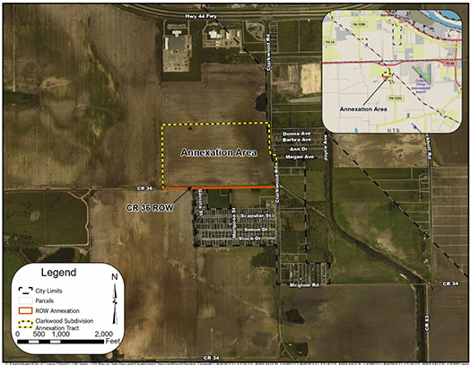
Clarkwood Estates and a portion of County Road 36 Annexation
The City Council will be holding a public hearing on the annexation of an approximately 87.57-acre tract of land located at the northwest corner of County Road (CR) 36 and Farm-to-Market Road (FM) 2292/Clarkwood Road and for the annexation of a 1.254-acre or 2,590 linear foot section of the CR 36 right-of-way that abuts the property’s southern boundary, which will bring the properties into the territorial limits of Corpus Christi.
The annexation area encompasses land that is currently in the City’s Extraterritorial Jurisdiction (ETJ). The ETJ promotes and protects the general health, safety, and welfare of persons residing in and adjacent to the municipalities.
For more information, contact Annika Yankee at AnnikaG@cctexas.com or by phone at (361) 826-3452.
Public Hearing Notice for Annexation